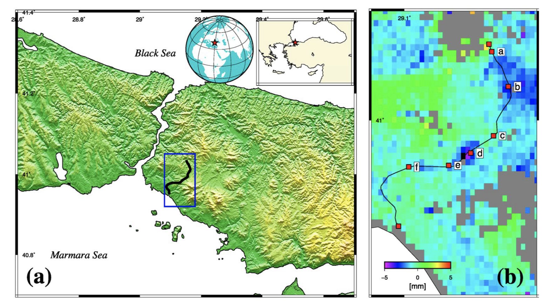
Turkey, as a developing country, is designing and performing massive construction projects around Istanbul. Beginning from the 1960s, rapid urbanization has been taking place due to industrialization, which brings an increase in the population. Yet, construction projects have been accelerated especially during the last decade, and many new projects are scheduled to be completed in a short time. Ground-based observations are generally carried out to monitor the deformations within construction sites, especially through geometric levelling, and GNSS techniques. However, in most cases, these monitoring measurements are only scheduled within the period of the construction process, and ensuing deformations are usually not considered. In addition to these techniques, the space-based interferometric technique can also be used to define the line of sight surface displacements with high accuracy, using the phase difference between image result for synthetic aperture radar images. In particular, Persistent Scatter Interferometry is one of the interferometric methods that are capable of defining the two-dimensional (vertical and horizontal) deformation for the desired epoch with a high temporal resolution. Thus it can be used as a complementary method for monitoring ground deformations, where the measurement is made by ground-based observations. In this study, the deforming areas related to underground metro construction are investigated through significant displacements between 2015 and 2018 of Sentinel-1 space-borne SAR data using the PSI technique. These results are validated by comparison with available levelling data corresponding to the new metro line.
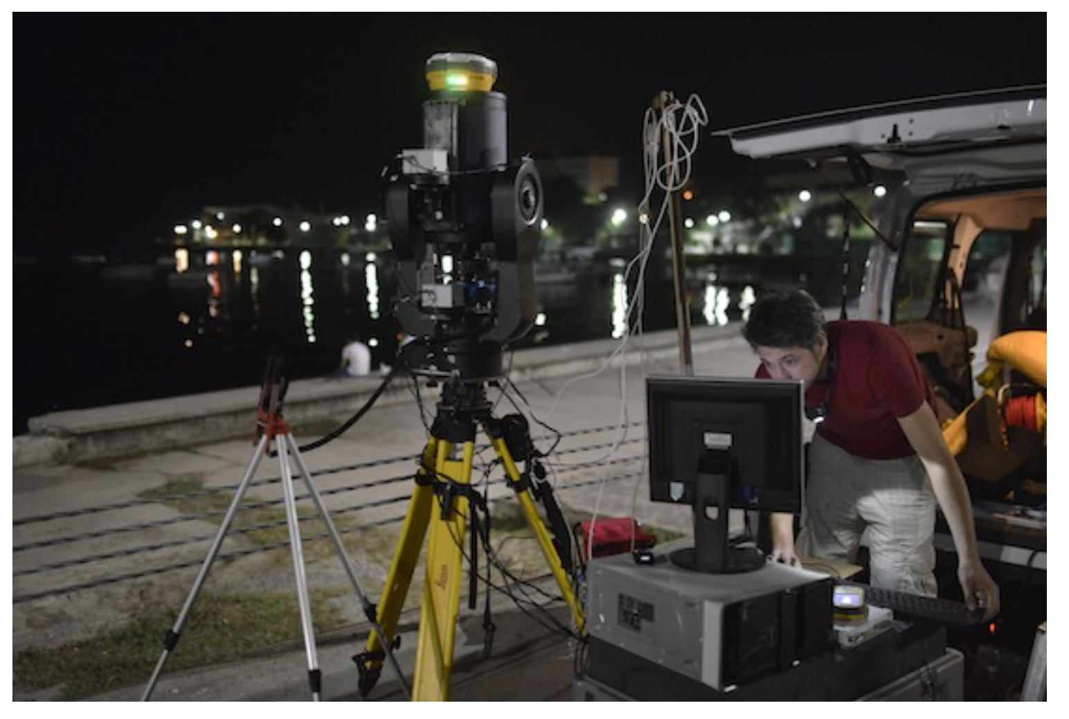
We present the first high-precision astrogeodetic vertical deflection (VD) observations collected in Istanbul, Turkey, using a novel lightweight total station integrated with a charge-coupled device (CCD) camera, the QDaedalus system. The observed VDs are unique in that, they were measured for the first time in Istanbul, and they form Turkey’s first dense astrogeodetic network. To establish the Istanbul Astrogeodetic Network (IAN), we selected 30 benchmarks (BMs) with known geodetic coordinates. A total of 21 of these BMs are located in the coastal zone allowing us to investigate the quality of global gravity field models (GGFMs) along the coast of Istanbul. The standard deviations for our VDs are approximately ±0.20 which is commensurate with the VD accuracy of early studies assessing the QDaedalus observations. In particular, dedicated comparison measurements were conducted in two geographic regions—Munich and Istanbul—to control the accuracy of the VD measurements. Our new VD data set within the IAN was compared with predicted VDs from the Global Gravity Model plus (GGMplus) and the Earth Gravitational Model 2008 (EGM2008). The VD residuals between the QDaedalus observations, and predicted values from GGMplus and EGM2008 models tend to increase towards the coastlines, where discrepancies of several arcseconds were found. At 15 coastal BMs, the residuals in the N-S components exceed 2 and reach values as large as 6, while residuals in the E-W components exceeded 2 at 3 BMs. We interpret these large differences as an indication of the current weaknesses in the GGFMs, most likely reflecting errors in the altimetry-derived marine gravity measurements, which have been incorporated in the EGM2008 and GGMplus models, or the lack of coastal terrestrial gravity measurements, or both. We conclude that the astrogeodetic VDs observed by the QDaedalus are invaluable for independently assessing the quality of coastal-zone terrestrial gravity data sets and GGFMs.
The Istanbul GPS Triangulation Network (IGTN) and the Istanbul Levelling Network (ILN), established in 2006, provide data for the determination of a local GNSS/levelling geoid model. These networks' measurements were done separately on both the Asian and European sides of the Bosphorus Strait in the vicinity of Istanbul. To connect these regions for those networks, a Valley Cross Levelling (VCL) data set, acquired in 1986 and 2004, was used. The use of this VCL data set was challenging in calculating the Istanbul geoid model, primarily because of its errors. In this study, this challenge was overcome through newly collected VCL data in 2010, allowing for the readjustment of the ILN and the newly collected VCL data set. The Istanbul geoid model was computed using soft computing techniques including the adaptive-network-based fuzzy inference system (ANFIS) and the artificial neural networks (ANNs). The resulting Istanbul GNSS/levelling geoid model is shown to be more reliable when compared with the model computed using conventional interpolation techniques.
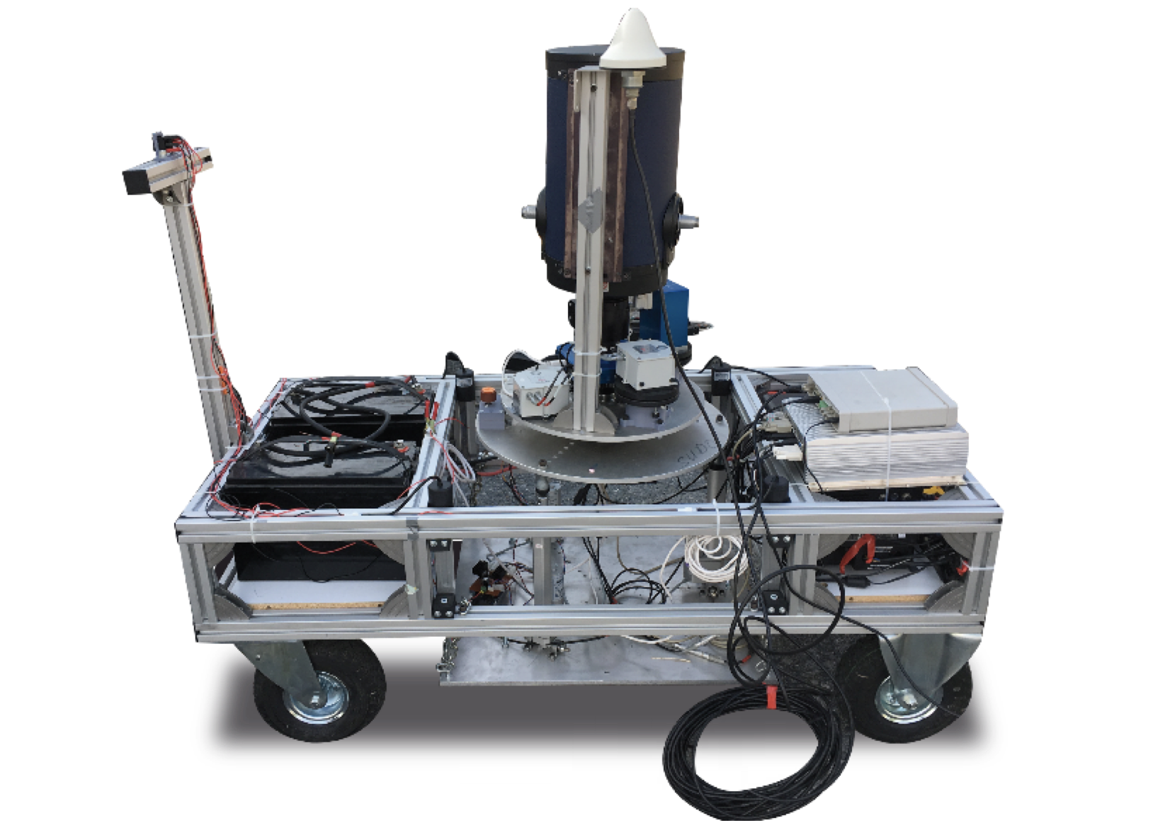
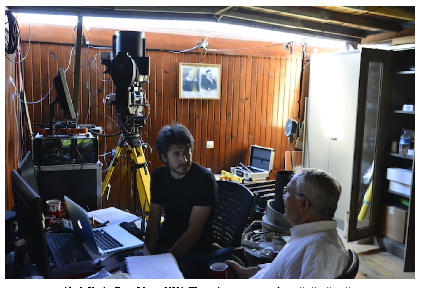
The Digital Zenith Camera Systems (DZCSs) are dedicated astrogeodetic instruments used to obtain highly accurate astrogeodetic vertical deflection (VD) data. The first Turkish DZCS, the Astrogeodetic Camera System (ACSYS), was developed in Istanbul, Turkey in 2015. The ACSYS was capable of determining astrogeodetic VDs with an accuracy of ~0.3 arcseconds. However, it had some limitations in observation duration: because of the semi-automated mechanical design, levelling the system towards zenith was a time-consuming process. Since 2016, the ACSYS has been modernized through system upgrades and new technological components. In this paper, we describe the instrument design of the new DZCS—ACSYS2—observation procedures, evaluation of the test data and calculations of these data. The preliminary ACSYS2 astrogeodetic test observations were conducted at Istanbul Technical University (ITU) test station. The standard deviation results of the repeated observations reveal a VD measurement precision of ~0.3 arcseconds for both the North-South and East-West components. To investigate the accuracy of the system, a lightweight total station based-geodetic system—QDaedalus—was also used at the ITU test station. The comparison of the VDs data between ACSYS2 and QDaedalus system shows that the ACSYS2 can produce reliable VDs data.
This study introduces the new results of a novel low-cost digital zenith camera system operated in Turkey that uses astronomical and geodetic instrumentation. Currently, it is possible to determine deflections of the vertical (DoV) components by using a vast amount of information gathered from geo-referenced star images, tilt measurements, and Global Navigation Satellite System technology. This new design of an astro-geodetic camera system is used for calculating DoV components with 12 independent solutions on a test station in Istanbul, and additional observations were performed to investigate the external accuracy of the system on a test network. A specific leveling method is developed to align system toward the zenithal direction. The final results of the observations on a test station located in Istanbul indicate that the accuracy of the system is about ±0.19 arc-seconds in latitude and ±0.28 arc-seconds in longitude determination. The system has been further tested on a network with 4 control points that have averagely 20 km baselines. At the test network, the root mean square of the average value of the vertical deflections is calculated as ±0.36 arc-seconds. Furthermore, DoV components are compared with the values that are calculated using global geopotential models.
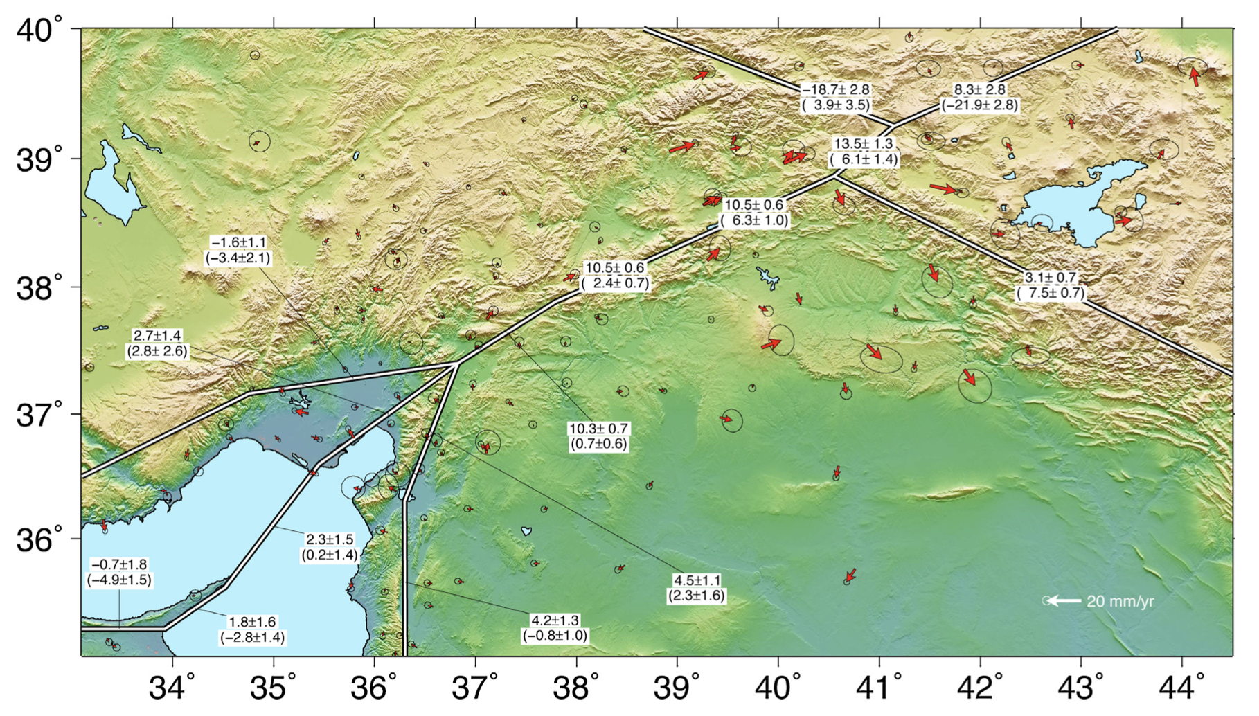
The East Anatolian Fault System (EAFS) is the second major fault system in Turkey, following the North Anatolian Fault System (NAFS). Unlike the NAFS, which produced 11 large earthquakes in the last ∼75 years, the EAFS has been relatively quiet during the same period of time. While historical records show that the EAFS has the potential to produce large earthquakes, the fault slip rates on the EAFS were not studied in detail, and were not quantified sufficiently. This is possibly due to the relatively low seismicity and slow slip-rates of the EAFS with respect to the NAFS. However, the determination of the slip rates of the EAFS is equally important in order to understand the kinematics of the Anatolian plate.In this study, we collected and analyzed new survey-type GPS data, and homogeneously combined published velocities from other studies, to form the most complete GPS data set covering the EAFS. In particular, continuous GPS observations were utilized for the first time to study the northern part of the EAFS. The results of the analysis give well-constrained slip rates of the northwestern segments of the EAFS, which is further connected to the Dead Sea Fault System (DSFS) in the south.The results show that while the slip rate of the EAFS is nearly constant (∼10 mm/yr) to the north of Turkoglu,it then decreases to 4.5mm/yr in the south.The slip rate on the northern part of the Dead Sea Fault System (DSFS) was also found to be 4.2 ± 1.3 mm/yr, consistent with earlier studies. The contraction rates along the EAFS are below 5 mm/yr, except for the northernmost part near Karliova, where it reaches a maximum value of 6.3 ± 1.0 mm/yr. The results also show that two well-known seismic gaps across the EAFS,Palu-Sincik and Celikhan-Turkoglu segments,have slip deficits of 1.5m and 5.2m and have the potential to produce earthquakes with magnitudes of Mw7.4 and Mw7.7, respectively.
There are several current investigations on gravity field of the earth in Geodesy and Geophysics. Earth sciences and space researches are also interested in gravity studies. Geoid, which approximately has an equal potential to the potential of mean sea level, is the main datum for height systems and is used for coordinate transforma- tion, reduction of measurements, subsurface density variations and similar scientific studies. Current studies focus on the determination of cm level geoid, in order to use Global Navigation Satellite Systems (GNSS) such as Continuously Operating Reference Stations (CORS-TR/TUSAGA-Active) in Turkey effectively. This study in- troduces general information about recent astro-geodetic observations performed by different institutions all over Europe. Furthermore, it also gives some details about data acquisition, instrumentation and processing technique that focuses on observation principle and new technologies used in modern Geodetic Astronomy. Finally, this study introduces the system design and the first observations of a Digital Zenith Camera System (DZCS) used in Istanbul, Turkey.

Both seismological and geodynamic research emphasize that the Aegean Region, which comprises the Hellenic Arc, the Greek mainland and Western Turkey is the most seismically active region in Western Eurasia. The convergence of the Eurasian and African lithospheric plates forces a westward motion on the Anatolian plate relative to the Eurasian one. Western Anatolia is a valuable laboratory for Earth Science research because of its complex geological structure. Izmir is a large city in Turkey with a population of about 2.5 million that is at great risk from big earthquakes. Unfortunately, previous geodynamics studies performed in this region are insufficient or cover large areas instead of specific faults. The Tuzla Fault, which is aligned trending NE–SW between the town of Menderes and Cape Doganbey, is an important fault in terms of seismic activity and its proximity to the city of Izmir. This study aims to perform a large scale investigation focusing on the Tuzla Fault and its vicinity for better understanding of the region's tectonics. In order to investigate the crustal deformation along the Tuzla Fault and Izmir Bay, a geodetic network has been designed and optimizations were performed. This paper suggests a schedule for a crustal deformation monitoring study which includes research on the tectonics of the region, network design and optimization strategies, theory and practice of processing. The study is also open for extension in terms of monitoring different types of fault characteristics. A one-dimensional fault model with two parameters – standard strike-slip model of dislocation theory in an elastic half-space – is formulated in order to determine which sites are suitable for the campaign based geodetic GPS measurements. Geodetic results can be used as a background data for disaster management systems.